If I were going to walk the Coast to Coast (which, splendid walk as it
is, I'm not contemplating at present), I would take two guides with me, and
one of them would be Tony and Chris Grogan's latest book: "A Coast to Coast
Route Guide".
I say this because it does the job. I do not think it would be possible
to have a clearer guide to prevent me going astray. The guide achieves this
by strip maps aligned in the general direction of travel. These maps are
based on the OS Explorer maps with superfluous detail omitted and some
features exaggerated for clarity.
The strip maps also include alternative routes, and Wainwright's original
route where it diverges from the present route. There is commentary
(including brief notes on features of interest) at the side of the strip
maps and many enjoyable photographs.
So Tony and Chris's book would quite definately go in my map pocket. And
the other book? Well, of course it would be Wainwright's original "A
Coast to Coast Walk".
"A Coast to Coast Route Guide" by Tony and Chris Grogan was published
in early 2014 by Skyware Press, cost £9.99 and available at bookshops and
www.skyware.co.uk
A Coast to Coast Route Guide by Tony &
Chris Grogan £9.99, published by Skyware (ISBN 978 0 9559987 8 2) - www.skyware.co.uk
It is a brave man or woman who follows, literally, in the footsteps of
the great Alfred Wainwright to write and in this case also publish, a guide
to his most famous walk across England, the Coast to Coast, 190 miles from
St Bees to Robin Hood's Bay.
In fact Chris and Tony Grogan are not the first to do so, and their
excellent introductory essay on the route indicates there are no less than
five existing versions by different authors, including a new version of the
original Wainwright guide with its hand drawn maps. So this becomes the
sixth. Like the Dales Way the route is a National Trail in all but name, and
is Britain's most frequently walked long distance route. Also like the Dales
Way, the route is now managed by a voluntary group, in this case the
Wainwright Society and route improvements are made from time to time, surely
something the master himself would have approved. In another break with
tradition, common sense has prevailed, and in 2012 the route was waymarked
for the first time since the publication of A Coast to Coast
Walk in 1973.
Sensibly the Grogans do not try and imitate AW's exquisitely executed
maps and drawings, but use a very clear OS map base with clear instructions
on the map, sharply evocative photographs and interpretive details in the
text alongside. The A5 size, standard for Skyware guides, is handy for
rucksacks or hand use, and the glossy paper is at least water resistant,
though a map cover is sensible in the UK climate.
Described as one of the world's great walks, the Coast to Coast path
allows the walker to experience three of England's finest National Parks -
the Lakes, North York Moors and of course Swaledale in the incomparable
Dales, including a section through the lovely Orton Fells which, politicians
willing, will soon form part of the extended Dales National Park. The guide
also uses the new sections of field paths rather than roads between Richmond
and Ingleby cross, though Wainwright purists can stay on the tarmac. With a
penny change from a tenner and produced to the usual Skyware high standard,
this route guide is exceptional value and the perfect introduction and
practical guide for the route, even for those of us who cherish our battered
copy of Wainwright.
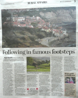
Roger Ratcliffe meets a couple from
Bradford who have written the definitive guidebook to Wainwright's Coast to
Coast.
When a hiking path is mentioned in the same company as the trek to
Everest Base Camp in the Himalayas and the Inca Trail of Peru you know it
must be something pretty special.
Country
Walking magazine named the route from St Bees Head in Cumbria to Robin
Hood’s Bay on the Yorkshire coast the second-best walking experience on the
planet – beaten only by one in New Zealand – but Chris Grogan didn’t need
any official blessing to appreciate its excellence.
“There’s a romance about it for sure,” she says. “Doing the Coast to
Coast for the first time back in the 1990s is still in my mind one of the
top memories of my whole life. It was emotionally very powerful to walk from
one side of my country to the other.”
She and her husband Tony have now completed the 190-odd mile path three
times, most recently for the purposes of writing a new guide to the route.
They are well-known in the walking world as the creators of the 90-mile
Dales High Way which starts near their home in Saltaire, Bradford, and
finishes at Appleby-in-Westmorland.
Since being devised by the Lakeland guidebook author Alfred Wainwright in
1973, the precise line of the C2C, as it has become known, had been altered
in numerous places. The Grogans’ new book is the first one to describe the
final course.
It runs across three National Parks – the Lake District, Yorkshire Dales
and North York Moors – and is divided into 12 daily sections. The longest is
a 23-mile stretch across the flat Vale of Mowbray from the town of Richmond
to Ingleby Cross on the edge of the North York Moors, while the shortest is
a lovely 11-mile moorland traverse of Swaledale from the timeless hamlet of
Keld to the picturesque village green at Reeth.
With an estimated 7,000 people now completing it every year, the C2C is
thought to be the most popular long-distance walk in the UK, eclipsing even
the mighty Pennine Way.
Alfred Wainwright, in fact, came up with the idea for the Coast to Coast
route after he had returned from the Pennine Way because he wanted his next
major walk to be more enjoyable. After doing the 270-mile hike from Edale in
the Peak District to Kirk Yetholm in the Scottish Borders he had complained
of floundering in peat bogs, stumbling in soggy heather and squelching in
muddy fields. Four years later, when he published his A Coast to Coast Walk
guide, he remarked: “I finished the Pennine Way with relief, the Coast to
Coast with regret.”
Almost immediately his book ran into problems with some farmers and
landowners along the course of C2C.
In several places he had ignored the inconvenient truth that there was no
legal right of way.
For Tony and Chris Grogan, producing their guide to Wainwright’s walk
meant working closely with rights of way officers in the National Parks and
local councils.
Says Tony: “Probably because Wainwright’s home stamping ground was the
Lake District, where you can walk anywhere above the intake walls, he kind
of took that mentality to places in the Pennines and Yorkshire Dales where
it just wasn’t the case. But, strangely enough, when the Right to Roam law
came into effect in 2000 some parts of his original route finally became
legal, so maybe he was ahead of his time.”
Wainwright died in 1991 at the age of 84, but in 2010 his publishers
produced a revised edition of his book to reflect route changes. Since then
amendments have been made to the route described there, and these are
included in the Grogans’ book. However, for Wainwright purists his original
route is shown on their maps, where it is accessible.
When the Grogans first completed the C2C almost 20 years ago they carried
big packs of camping gear and got rained on every single day. But the
weather soon became insignificant, Chris says, while another factor was the
camaraderie which developed with others doing the walk.
They all managed to meet up for the grand finale at Robin Hood’s Bay and
a drink in the Bay Hotel, right on the finishing line.
Chris concedes that their own Dales High Way walk, like every other
long-distance path in the UK, has an arbitrary starting and finishing point,
while the C2C is unique because it is defined by the geography of England.
“When you reach the Yorkshire coast you just can’t walk any further. When
they set out from St. Bee’s many people like to dip their feet in the Irish
Sea, and when they reach Robin Hood’s Bay they get their boots off for a
paddle. Standing there with your feet in the water gives you a wonderful
sense of achievement.”
Route guide available now
A Coast to Coast Route Guide by Tony & Chris Grogan is published by
Skyware, price £9.99. Available from bookshops and online at
www.skyware.co.uk
For up-to-date information about any temporary route diversions,
accommodation, baggage carriers, public transport etc, visit
www.coastto.co.uk
Footsteps - The Wainwright Society
Magazine, Spring 2014
Book Review by David Johnson, editor
A Coast to Coast Route Guide
by Tony & Chris Grogan
The authors of this well-produced book are Society members. It includes
an informative introduction to and history of Wainwright's Coast to Coast
Walk, the route being divided into twelve sections. Each is helpfully
detailed by commentary, photographs and linear maps with useful annotations
to assist the walker in following or varying the route.
It is a practical guide for those contemplating this walk, but would make
a fine memento for anyone who has completed it.
ISBN: 978-0-9559987-8-2. Published by Skyware Ltd. £9.99
Price: £9.99 Author: Tony and Chris Grogan ISBN number: 978 0 95599878 2
A slim, pocket-size guide to Wainwright's Coast to Coast walk which
depicts the popular route via a series of large-scale colour strip maps, all
very clearly set out and easy to follow. It incorporates all the recent
route modifications on the classic walk from St Bees Head to Robin Hood's
Bay, plus there are colour photos and supporting text (including a history
of the walk) to help you find your way.
A COAST TO COAST ROUTE GUIDE, by Tony and Chris Grogan, £9.99,
ISBN 978-0-955998782
Wainwright’s Coast to Coast walk is without doubt one of the most popular
and most-often trekked long distance trails in Britain.
From the Irish Sea at St Bees Head, it winds its way to the shoreline at
Robin Hood’s Bay in North Yorkshire, taking in a good swathe of the Lake
District National Park en route.
This book describing the route is packed full of thorough and
comprehensive detail – from a brief history of the Coast to Coast Walk to
thoroughly usable map guides.
The strip maps are aligned in the general direction of travel and the
route was surveyed on the ground prior to publication.
The full colour large-scale strip maps of the entire route and stunning
images throughout the guide will make the practical task of finding your way
across England easy.
The handy book also comes equipped with a weather resistant wallet - just
in case you get caught out in the rain.
A Coast To Coast Route Guide
By Chris and Tony Grogan
Skyware, £9.99
One day I will walk across Northern England from St Bees Head on the
Irish Sea coast to Robin Hood’s Bay, approximately 190 miles westwards on
the North Sea coast.
Well,
that’s what I like to think. Sometimes. But if ever I decide that the time
has come to walk from the place where the sun sets to the place where it
rises, I will reach for the latest splendidly illustrated publication from
Chris and Tony Grogan’s Saltaire-based Skyware company.
A Coast To Coast Route Guide follows in the footsteps of Alfred
Wainwright, setting out for the intrepid hiker a dozen scenic routes from
the Lake District to the North Yorkshire Moors, the longest being 23.2 miles
from Reeth to Richmond. The shortest is 10.7 miles from Keld to Reeth.
“Since Wainwright’s Coast To Coast Walk was first published in 1973,
there have been a number of changes to the route” say the Grogans.
“Despite Wainwright’s intention to ‘use only rights of way and areas of
open access’, his route in places followed tracks across private land that
were not rights of way. This became a particular problem in the section
between Shap and Kirkby Stephen.
“The authorities were later able to negotiate permissive status with land
owners on some tracks which allowed their continued use. In other places
this was not possible.
“Elsewhere, Wainwright’s route problems were of an entirely different
nature. Many of the rights of way across the Vale of Mowbray were neglected
and inaccessible. Wainwright found himself ‘beaten back to the tarmac by
barbed wire, dykes, too-friendly bovines and other obstacles’.
“He was forced to revert to quiet country roads for more than eight
miles. Today things are much improved, and the modern route now follows
easily along grassy footpaths for most of this section, just as Wainwright
originally intended.”
The Wainwright Society, founded in 2002, has been talking to all the
local authorities with a view to waymarking the route that threads them once
and for all. This is the route mapped out by Chris and Tony Grogan.
They actually do more than that, as users of their previous guides will
know. Each coloured relief map contains little red bordered boxes offering
advice: “Nip under the arches to see Old Beggar’s Bridge”.
There are warnings too: “Don’t bear right too early to avoid hitting a
dangerous scree slope.”
It’s as close to walking with Satnavs as you’re likely to get.
Alfred Wainwright died at the age of 84. His ashes were scattered at
Innominate Tarn, on Haystacks. In Memoirs Of A Fellwalker, Wainwright said:
“All I ask for, at the end, is a last long resting place by the side of
Innominate Tarn, on Haystacks, where the water gently laps the gravelly
shore and the heather blooms and Pillar and Gable keep unfailing watch. A
quiet place, a lonely place.
“I shall go to it, for the last time, and be carried – someone who knew
me in life will take me and empty me out of a little box and leave me there
alone. And if you, dear reader, should get a bit of grit in your boot as you
are crossing Haystacks in the years to come, please treat it with respect.
It might be me.”


 Country
Walking magazine named the route from St Bees Head in Cumbria to Robin
Hood’s Bay on the Yorkshire coast the second-best walking experience on the
planet – beaten only by one in New Zealand – but Chris Grogan didn’t need
any official blessing to appreciate its excellence.
Country
Walking magazine named the route from St Bees Head in Cumbria to Robin
Hood’s Bay on the Yorkshire coast the second-best walking experience on the
planet – beaten only by one in New Zealand – but Chris Grogan didn’t need
any official blessing to appreciate its excellence.  Well,
that’s what I like to think. Sometimes. But if ever I decide that the time
has come to walk from the place where the sun sets to the place where it
rises, I will reach for the latest splendidly illustrated publication from
Chris and Tony Grogan’s Saltaire-based Skyware company.
Well,
that’s what I like to think. Sometimes. But if ever I decide that the time
has come to walk from the place where the sun sets to the place where it
rises, I will reach for the latest splendidly illustrated publication from
Chris and Tony Grogan’s Saltaire-based Skyware company.