

 Dales
Rail Trails
Dales
Rail Trails
by Tony & Chris Grogan
ISBN: 978-1-911321-03-3
Published by: Skyware Ltd.
2nd Edition
Date of publication: January 2020
Price: £9.99
Paperback, A5, 210 mm x 148 mm, Stitch fold.
Full Colour
84 pages with 55 colour photos, 22 detailed colour route maps and 20 other maps.
Each copy comes in a free (optional) weather-resistant plastic wallet.
Explore the glorious high country of the Yorkshire Dales - by train!
32 walks from stations along the world famous Settle-Carlisle line, the most beautiful railway in England. Full colour maps at a scale of 1:25,000, with concise descriptions of the routes and places along the way.
What better way to enjoy a holiday than to base yourself at a village on the line and use the train to explore the stunning western Dales? Or reach the heart of this fabulous walking country from Leeds or Carlisle in little over an hour.
Also includes a guide to the Three Peaks Challenge Route and the 48-mile Six Peaks Trail.
So let the train take the strain while you enjoy the walk.
UK CUSTOMERS - Buy now from Skyware's online shop POST FREE
OVERSEAS CUSTOMERS - Buy now from Skyware's online shop: AIRMAIL COSTS APPLY

Each copy of the Dales Rail Trails book comes with a free (optional) handy
weather-resistant plastic wallet.


Bridget & David walk the Six Peaks Trail, September 2016


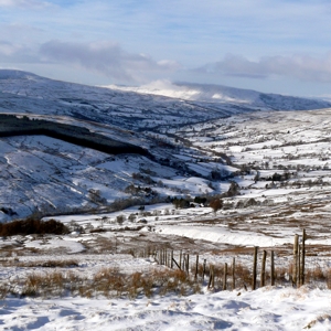


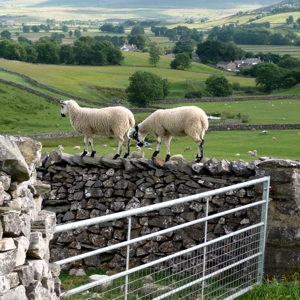


Scenes from Dales Rail Trails"It's colourful and well thought-out, with
inventive routes and decent 1:25,000 maps." "There is little doubt that this guidebook
will attract many more walkers to what is without question, some of the
finest fell walking country in Britain; an area which is also uniquely
accessible by one of the country's most spectacular railway lines" "The maps and instructions should give even
the most novice walker confidence to follow the routes
independently." "The authors' knowledge and enthusiasm for
the area shine through this concise book of varied and contrasting
walks" "Walkers will be able to take advantage of
routes from stations along the famous Settle Carlisle rail line while
raising vital funds to preserve Yorkshire’s Three Peaks." 
A proportion of the proceeds from the sale of each copy of this book will be donated to the Friends of the Three Peaks. This money will be used to help improve and maintain the footpath network in the Three Peaks area. 
This project was originally funded by the Yorkshire Dales National Park Authority's Sustainable Development Fund, which is managed by the Yorkshire Dales Millenium Trust. |